
National
National
05 Nov, 2025
Severe Tropical Storm Opong May Strengthen as It Approaches the Philippines
Macario Yambao
Severe Tropical Storm Opong, locally known as Bualoi, sustained its strength over the Philippine Sea on the morning of Thursday, September 25, with the Philippine Atmospheric, Geophysical, and Astronomical Services Administration (PAGASA) cautioning that it could either remain a severe tropical storm or intensify into a typhoon while still offshore.
As of 10 a.m. Thursday, Opong was situated 335 kilometers east of Guiuan, Eastern Samar, moving west-northwest at 25 kilometers per hour—an acceleration from its previous speed of 20 kilometers per hour. The storm currently carries maximum sustained winds of 110 km/h and gusts up to 135 km/h, with typhoon classification starting at sustained winds of 118 km/h.
PAGASA's latest forecast indicates that Opong may pass near Northern Samar or make landfall in the Bicol region by Friday morning or early afternoon, September 26. The storm is expected to traverse Southern Luzon throughout Friday, possibly weakening over land but continuing to present a significant threat.
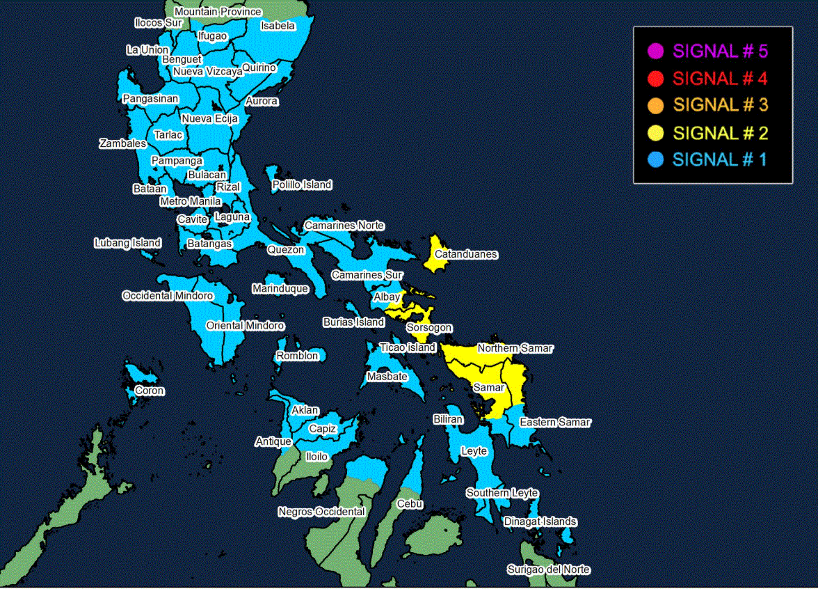
An updated rainfall outlook warns of moderate to torrential rains over the next 48 hours, particularly heavy in Eastern Visayas and Southern Luzon. Areas such as Northern Samar, Eastern Samar, Samar, Biliran, Sorsogon, and Masbate could receive above 200 millimeters of rainfall, while neighboring provinces are forecasted to experience between 50 to 200 millimeters.
Flooding and landslides are likely across these regions due to persistent heavy precipitation. Furthermore, tropical cyclone wind signals remain in effect across multiple provinces, with Signal No. 2 indicating gale-force winds (62 to 88 km/h) in portions of Bicol, Eastern Visayas, and Northern Samar, and Signal No. 1 signaling strong winds (39 to 61 km/h) across several other areas including Metro Manila and parts of Luzon.
Should Opong intensify into a typhoon, PAGASA notes the maximum possible wind signal could escalate to Signal No. 4. The enhanced southwest monsoon continues to generate strong to gale-force winds in northern and central Luzon, Palawan, Visayas, and parts of Mindanao, extending the storm’s impact beyond its immediate path.
There is also a moderate to high risk of "life-threatening" storm surges with peak heights estimated between one to three meters along coastal areas such as Metro Manila, Central Luzon, Calabarzon, the Bicol region, and Eastern Visayas over the next 36 hours.
Sea conditions will worsen significantly as Opong approaches, with some coastal areas experiencing waves up to 11 meters high, creating hazardous conditions for maritime activities.
Opong is the 15th tropical cyclone to enter the Philippine Area of Responsibility (PAR) in 2025 and the fifth in September. After crossing Southern Luzon, the storm is anticipated to move into the West Philippine Sea, where it may strengthen further before potentially exiting the PAR on the afternoon or evening of Saturday, September 27.
Meanwhile, the southwest monsoon continues to bring scattered rain and thunderstorms, especially in Mimaropa, Western Visayas, and some western parts of the country including Metro Manila.
Residents and local authorities are urged to remain vigilant and monitor official advisories as Opong progresses.
Recommended For You
Philippine Flood Control Scandal Highlights Urgent Need for Governance in Family Businesses
Nov 05, 2025
Nemesio Gatdula

EU Orders France to Reclaim €1.8 Million from Ryanair Over Illegal State Aid
Nov 05, 2025
Basilia Magsaysay

DILG Secretary Remulla Denounces Violence Amid Predominantly Peaceful Sunday Protests
Nov 05, 2025
Nemesio Gatdula

Obando Church Returns Donated Vehicle Amid Corruption Allegations Against Former DPWH Engineer
Nov 05, 2025
Nemesio Gatdula